Urban GPS experience
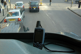
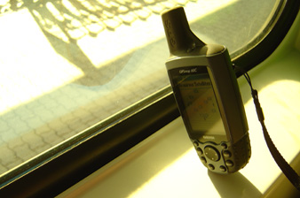
The Garmin GPS Map 60c fits in an old Marimekko bag in a mobile-phone pocket just small enough that the aerial sticks out. Placed like that in the windows of buses or cars it doesn’t slide around, and I can walk with it without looking like a geek or getting mugged.
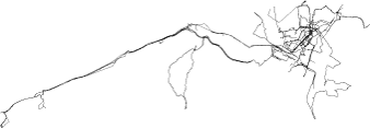
Three months of trying to record a clean dataset of GPS tracks to geo-locate my photography, in Oslo and London. Notes on what the Garmin does and doesn’t do in dense European cities, from the perspective of a pedestrian on the pavement or in public transport.
Problems
GPS doesn’t work well in dense urban environments. From a car it seems fine, probably because of the clear sky in the middle of the road, but for a pedestrian on the pavement the signal drops constantly. Inclement weather and green trees also get in the way.
In the last few months, trying to record a good-quality database of tracks, I must have looked really odd. Face in device, stopping on street corners, stopping in the middle of street crossings, scrambling to grab the front seat of the bus. Discovering that GPS doesn’t just passively work is a disappointment; my dataset is clouded with gaps and anomalies.
Some other observations
- Fast turns on public transport or in a car produce wild deviations: re-acquiring the satellites is the problem
- A road needs to align with at least 4 satellites for an acceptable track; otherwise errors accumulate
- Glass buildings produce ‘reflections’ of position, the track jumps elsewhere due to reflected signals
- I sit on the outside or front of buses to get a wider expanse of sky; I am constantly aware of sky cover
- The relative position of satellites is beginning to affect which side of the street I walk on
- Walking in the middle of the street has led to a couple of near misses with cars. The moving map is just too engaging
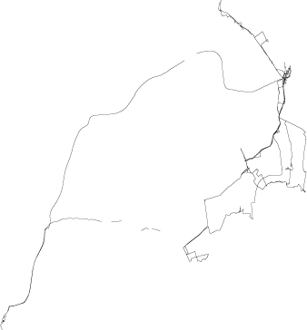
- I’d like an explanation of the lost-track calculation: this device seems to use the last-known bearing and velocity to guess new tracks when the signal fails, which is unreliable and fills the map with phantom trails
- The track itself can be more useful over time than the base map. It shows my personal space and personal routes. Popular routes build up in blackness and thickness. The area around home becomes an abstract scatter plot that’s strangely familiar
- Stored waypoints are useful for getting rough bearings: zooming out and seeing the relationship to two known landmarks can orient you in an unknown area