Locative Media
12 posts tagged.
-
Art + communication 2004
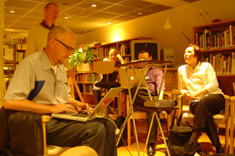
Notes from Art + Communication 2004, organised by RIXC in Riga, Latvia, the final event in the Trans-cultural Mapping workshop series. Even Westvang and I presented our Timeland project. A trip to Limbazi for the opening of the Piens (‘milk’) project, milk routes through the EU, mapped through the personal stories of the people along them.
-
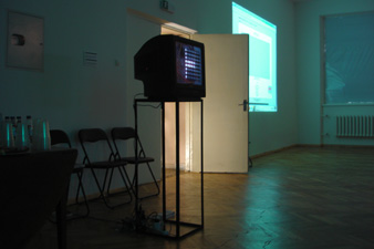
Time that land forgot
A 2004 project with Even Westvang from the Iceland inside-and-out workshop, a prototype for contextualising photographs by time and geography, designed to shift the balance of representation away from pure location and towards image and time.
-
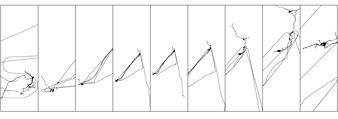
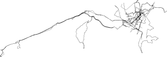
Photography and mapping from Afar
My contribution to ‘Afar’, an exhibition in Copenhagen where 25 international artists produced work to brief. For three months I recorded every walk, drive, train journey and flight I took while photographing daily life. Nine boards of images paired with GPS tracks drawn as simple lines show the transition from London to Oslo across a winter and spring.
-
Geo-referenced photography
The simplest way to link a photograph to a location is to combine two time-stamps: one from the digital camera, one from the GPS receiver. Given both sets of timestamps over the same period, a series of images and tracklogs can be processed to stamp each image with location metadata. Compiled in July 2004 at the Hofn workshop in Iceland, during the work that became Time that land forgot . A working reference list of papers, projects, guidelines, tools and the technical issues that surrounded geo-referenced photography at that moment. Most of the links below are now dead; the list is preserved as a snapshot of what the state of the art looked like in 2004. Position-annotated Photographs: The Geotemporal Web GEOREP: Digital Library for Spatial Data Geographic location tags on digital images, Microsoft Portable digital photo album Tokyo Picturesque ( details ) Habitat Perspectives Photo Location ( metadata notes ) Geo Snapper WWMX web demo Good list of other photo mapping projects Commercial applications and scripts that link photographs to geographic information: Robophoto 93 Photo Street Photofusion Media Mapper OziPhotoTool GPS photo link GPS TrackMaker QuakeMap WWMX Travelogue app…
-
Iceland inside/out workshop
A very short 2004 note from Reykjavik, where I was attending the Trans-cultural Mapping workshop. This workshop was where the ‘Time that land forgot’ project with Even Westvang was made.
-
Mobile outskirts workshop
A bus full of GPS receivers, cameras and impromptu artworks drove fifteen hours from Trondheim up to the islands of Lofoten. The workshop wiki and media archive are being kept updated via fairly limited wireless coverage. A short dispatch from the Mobile Outskirts workshop in Lofoten, June 2004, part of the Trans-cultural Mapping workshop series . A painless and creative bus drive up the Norwegian coast.
-
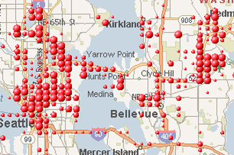
Mobile social software applications
A list of mobile social software applications from 2004: Jabberwocky tracking familiar strangers, Fluidtime routing public transport in Turin, Dodgeball pinging your friends when they’re within ten blocks of you, Plazes tagging your location for the public, Mamjam chatting with others at the same venue by SMS. The first wave of location-aware social services, before smartphones. A growing list I compiled in June 2004 during early PhD research into mobile and locative systems. Descriptions below are taken from each project’s own site. Most of the projects are long gone; the list is preserved as a snapshot of what mobile social software looked like before the iPhone. Companion to the spatial annotation projects list . This research project explores our often ignored yet real relationships with Familiar Strangers. We describe several experiments and studies that lead to a design for a personal, body-worn, wireless device that extends the Familiar Stranger relationship while respecting the delicate, yet important, constraints of our feelings and relationships with strangers in pubic places. A visualization tool based on Mobster that enables users to explore their social encounters in new ways.
-
Spatial annotation projects
A reference list I compiled in June 2004 during early PhD research into locative media and spatial annotation. It includes Murmure in Vancouver’s Chinatown, Yellow Arrow stickers, Grafedia’s hyperlinked handwritten text, Urban Tapestries and dozens of others. The list is preserved as a snapshot of a field at a particular moment.
-
Transcultural mapping workshops
A brief announcement from May 2004. Two workshops on the calendar this summer. The Transcultural Mapping workshop (‘Mobile outskirts: cultural mapping of northern geographical outposts’), in Lofoten in June, looking at GPS and photography in remote Norwegian coastal places. The Loop City workshop at the Outside In symposium (‘Emerging expressions, interventions and participation in public space’) in Gothenburg shortly after, on walking and mapping urban public space with Bill Hillier of Space Syntax. Update: new workshop website .
-
Creative Crossings workshop
A triangular research network, practitioners from Britain, Canada and Finland, gathered in London to work on participatory and creative applications for mobile, locative and cross-platform media. Organised by m-cult, the Banff Centre and Arts Council England in April 2004.
-
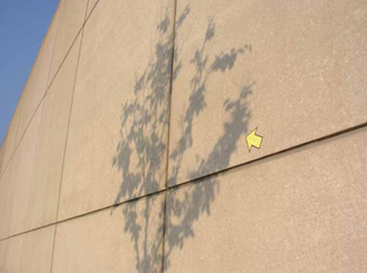
Urban GPS experience
Three months of trying to record a clean dataset of GPS tracks to geo-locate my photography, in Oslo and London. Notes on what the Garmin GPS Map 60c does and doesn’t do in dense European cities, from the pavement and from public transport.
-
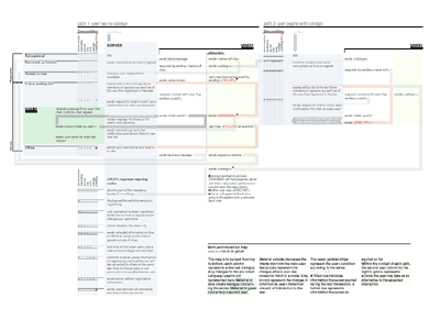
Mobile interaction design case study
A 2001 case study of consultancy work for Pollen Mobile, written up as it happened. Jack Schulze, Adi Nachman and I designed the interaction architecture for Mamjam, a location-based social entertainment service built on SMS, letting people in the same venue chat with each other by text.