Mapping
18 posts tagged.
-
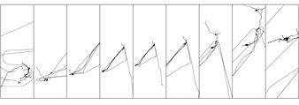
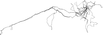
Parallel tracking and mapping for small AR workspaces
I love how it goes in and out of register, and how it ‘picks up’ the registration from an initial set of objects. People will end up intuiting that AR works in certain ways “not around trees” for instance, or only in “static scenes”. YouTube – Parallel Tracking and Mapping for Small AR Workspaces (PTAM) – extra .
-
Map/Territory
A short visual experiment that shows physical space overlaid with digital, manipulable map information.
-
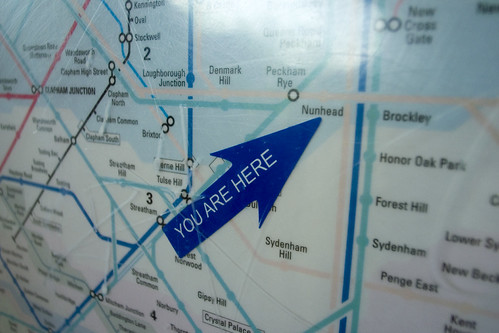
You are here
A 2006 note on collecting images of ‘you are here’ marks, or ideo locators, at Flickr. The relationship to local physical space is what makes them work: mapping with a point of view, maps as a direct interface to the world. The best example to date is from Seoul, where 3D cross sections of a metro station are directly related to the point at which you are looking at the map.
-
Spatial memory at Design Engaged 2004
Presentation notes from Design Engaged 2004 in Amsterdam. Two related strands: the Time that land forgot project with Even Westvang (five months, 8000 photos, visualised by date and time of day), and the research on marking in urban public space.
-
Design Engaged 2004
Twenty-odd designers, researchers and writers sat around a long table in Amsterdam over a weekend in November 2004, taking turns to present. These are my notes, session-by-session, as written at the time. Design Engaged 2004 was an invitation-only gathering organised by Andrew Otwell. A small, intense weekend of conversation that turned out to be one of the generative moments of the design-web at that period. The FAQ has the full list of attendees. There are also lots of photos on Flickr . The growth of the soil How do we comprehend complexity How do we build structures around complex information Accreting meta-data: GPS data, descriptive information Break down of material as it hits the soil Soup, tags, condensed and distilled meta objects Sorting mechanisms, affinity browsers, related, filtering, emergent relationships, interrelationships How do we conceive a metaphor for building these processes? A structure that is meaningful for the users. Application design: movement through states of application to tending a flow of processes Tending to meta-data is a growth process DLA: diffusion-limited aggregation, a natural process model The relationships between metadata can be visualised as this.
-
Art + communication 2004
Notes from Art + Communication 2004, organised by RIXC in Riga, Latvia, the final event in the Trans-cultural Mapping workshop series. Even Westvang and I presented our Timeland project. A trip to Limbazi for the opening of the Piens (‘milk’) project, milk routes through the EU, mapped through the personal stories of the people along them.
-

ISEA 2004 conference
A short 2004 note from ISEA, the International Symposium on Electronic Art, held that year on a Silja Line ferry between Helsinki, Stockholm, Mariehamn and Tallinn. Polarfront kept event notes through the run, and Grandtextauto covered the installations and artwork.
-
Time that land forgot
A 2004 project with Even Westvang from the Iceland inside-and-out workshop, a prototype for contextualising photographs by time and geography, designed to shift the balance of representation away from pure location and towards image and time.
-
Photography and mapping from Afar
My contribution to ‘Afar’, an exhibition in Copenhagen where 25 international artists produced work to brief. For three months I recorded every walk, drive, train journey and flight I took while photographing daily life. Nine boards of images paired with GPS tracks drawn as simple lines show the transition from London to Oslo across a winter and spring.
-
Iceland inside/out workshop
A very short 2004 note from Reykjavik, where I was attending the Trans-cultural Mapping workshop. This workshop was where the ‘Time that land forgot’ project with Even Westvang was made.
-
Loop city workshop
Bill Hillier at University College London describes cities as movement economies, the structure of a city is the pattern of people moving through it. The workshop took this as the starting point and spent two days walking that idea across related fields: spatial organisation, relative space, time-space, taxicab geometry, mental mapping, text maps. Notes from the Loop City workshop at the Outside In symposium in Gothenburg, Sweden, June 2004. The workshop was led by Dietmar Offenhuber and Sara Hodges with participants from the symposium, working across geography, architecture, mapping and locative media. Raw notes below. spacesyntax.com Space explorers : children, homeless, vendors, skateboarders Space utilisers : commuters, workers Exocentric : external, connected Egocentric : centred, point of view Large, diverse research field Abler, Adams and Gould: Spatial Organization: The Geographer’s View of the World Expressing thematic data through spatial differentiation Political maps based on size of army Map of USA based on Elvis concerts Irina Vasiliev: Design Issues for Mapping Time Time as a way of measuring space (one conclusion: the world is shrinking) Grid systems make diagonal m…
-
Mobile outskirts workshop
A bus full of GPS receivers, cameras and impromptu artworks drove fifteen hours from Trondheim up to the islands of Lofoten. The workshop wiki and media archive are being kept updated via fairly limited wireless coverage. A short dispatch from the Mobile Outskirts workshop in Lofoten, June 2004, part of the Trans-cultural Mapping workshop series . A painless and creative bus drive up the Norwegian coast.
-
Outside In
Outside In was a two-day forum at Röda Sten in Gothenburg on 14–15 June 2004, about new voices, media and practices in the design and use of public space. The venue is extraordinary: below a suspension bridge, surrounded by huge concrete creations. Really windy outside, calm inside the lecture space. These are my notes from the talks, written on the day. Occasional asides in italics are things I’ve added looking back. I’ve left the note form mostly as-is. (I missed the first workshop of the day.) Putting memories in spaces. Spaces aren’t the same after having been disrupted. After ‘Reclaim the Streets’ or a Circle Line party you can’t see the space in the same way. Distinction between public and private. What is it? Public space doesn’t exist anymore. Ken Livingstone’s new City Hall is half-private, half-public, private investment was involved in the building, so protests cannot happen outside. Do we need institutions in order to do events? Is that the only way to do them legally? What’s stopping people from doing these things is not necessarily capitalism but the fear of looking like a pillock. Self-regulation is a big factor. Can spark things to let down inhibitions or shackles. Example of the scooter, became a kids’ toy and then it wasn’t cool anymore.
-
Spatial annotation projects
A reference list I compiled in June 2004 during early PhD research into locative media and spatial annotation. It includes Murmure in Vancouver’s Chinatown, Yellow Arrow stickers, Grafedia’s hyperlinked handwritten text, Urban Tapestries and dozens of others. The list is preserved as a snapshot of a field at a particular moment.
-
Transcultural mapping workshops
A brief announcement from May 2004. Two workshops on the calendar this summer. The Transcultural Mapping workshop (‘Mobile outskirts: cultural mapping of northern geographical outposts’), in Lofoten in June, looking at GPS and photography in remote Norwegian coastal places. The Loop City workshop at the Outside In symposium (‘Emerging expressions, interventions and participation in public space’) in Gothenburg shortly after, on walking and mapping urban public space with Bill Hillier of Space Syntax. Update: new workshop website .
-
Public markup
Early PhD research into the marking of public space: the physical annotation of the city through stickering, graffiti and billboards. It looks for patterns in visibility, techniques, process, location, content and audience, and argues that the new short-range digital technologies, especially RFID, should be designed the same way. Not invisible.
-
Urban GPS experience
Three months of trying to record a clean dataset of GPS tracks to geo-locate my photography, in Oslo and London. Notes on what the Garmin GPS Map 60c does and doesn’t do in dense European cities, from the pavement and from public transport.
-
Travelogue
A 2004 note on treating digital photography as a narrative medium, sequences of photos that suggest movement, place, stories and journeys. With plans to tag each image with a GPS coordinate so the sequence carries place as well as time.